This fall, the threat of a “super” El Niño made national headlines. Forecasters called for flooding in California, drought in the Rockies, and a frigid winter in the Southwest. Now that snow has started to fall in Big Sky, let’s see how two long-range forecasts compare to the winter we’ve experienced thus far.
The Old Farmer’s Almanac
 The Old Farmer’s Almanac, the yellow-cover leaflet distributed at gas stations and hardware stores nation-wide, uses a long-range weather forecast based on a formula from 1792. Future weather trends and events are predicted by comparing solar patterns and historical weather conditions with current solar activity.
The influence of solar radiation on climate has been hotly debated. Most scientists agree that sunspot activity, which causes solar radiation to vary on an eleven-year cycle, has a slight influence on air temperature and atmospheric circulation. However, the importance of solar activity has been diminishing with the increase of greenhouse gases in the atmosphere.
Despite the lack of scientific consensus on the relationship between the sun and weather, The Old Farmer’s Almanac alleges that their forecast is 80% accurate. Clearly, they know a few things that the climate experts don’t.
The long-range forecast for the Intermountain Region called for warmer than average winter temperatures with precipitation near normal in the Northern Rockies. Cold periods were predicted for mid- and late December, late January, and mid- and late February while snow was predicted to fall in early and mid- December, early January, and mid- and late February.

Long-range forecast for 2015/2016 temperature and precipitation in the Intermountain region from The Old Farmer’s Almanac.
The NOAA Climate Prediction Center
 The National Oceanic and Atmospheric Administration (NOAA) based their 2015/2016 forecast on the effects of strong El Niño conditions developing in the Pacific Ocean. El Niño is characterized by above average sea surface temperatures in the equatorial Pacific Ocean; on the other hand, below average sea surface temperatures define La Niña.
The variation between these two modes is known as the El Niño-Southern Oscillation (ENSO), which is an important factor in predicting short-term (several months to a year) global climate. This winter, El Niño conditions are on track to be one of the three strongest on record.
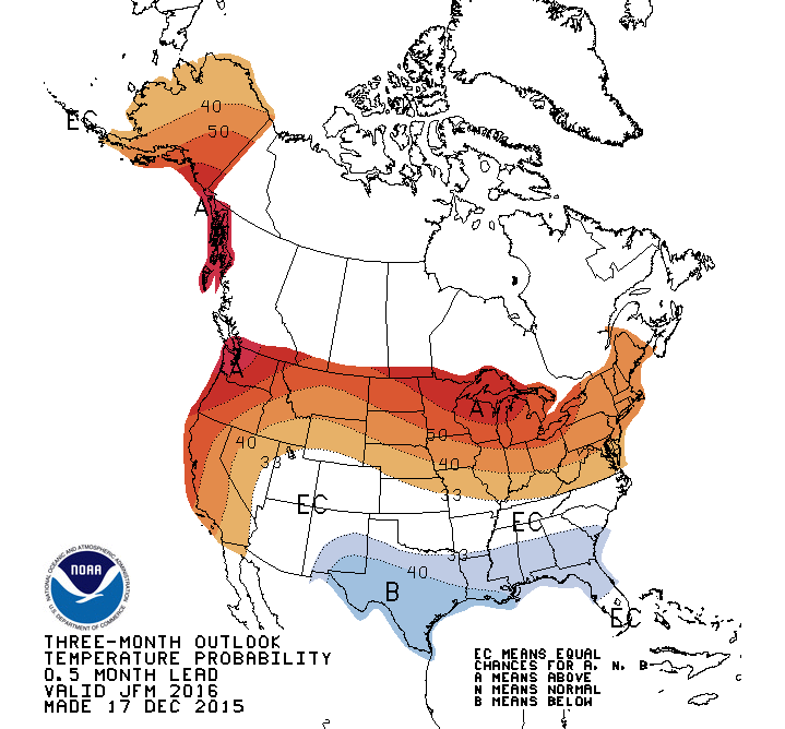
Pronounced warming in the Pacific Ocean strengthens and alters the path of the jet stream. Generally, this causes warmer and drier conditions in the Northern Rocky Mountains. According to the NOAA three-month outlook for the period from December to February there is a 40% probability of warmer than average temperatures and 50% probability of drier than average temperatures.

Three month temperature forecast for January to March from NOAA. A means above; B means belows; and EC means equal chances for A and B.
Big Sky Winter So Far
After a quick glance at the data from the Lone Peak SNOTEL station, winter temperatures at Big Sky Resort have been near normal while snowfall has been slightly below average. These conditions mirror those predicted by NOAA, and resemble the mild winter predicted by The Old Farmer’s Almanac. However, we have to wait a few more months to determine if winter conditions continue to emulate those predicted.

Plot of snow water equivalent (SWE) from the Lone Peak SNOTEL for the current water year to date. Average SWE shown in green. Observed shown in black.
Long-range weather prediction combines local knowledge, state of the art models, and collaboration with careful guess-work; however, each storm is unique. At best, forecasters can do little more than play the odds. The house always wins when you gamble with Mother Nature.
